Geolocate

Elden topographic map

Click on the map to display elevation.

About this map

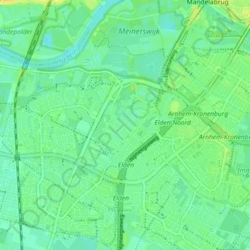
Name: Elden topographic map, elevation, terrain.

Location: Elden, Arnhem, Gelderland, Netherlands, 6842 AT, Netherlands (51.93820 5.86330 51.97820 5.90330)

Average elevation: 11 m

Minimum elevation: 3 m

Maximum elevation: 21 m

Other topographic maps

Click on a map to view its topography, its elevation and its terrain.

Sonsbeek

Netherlands > Gelderland > Arnhem

Average elevation: 43 m

Gear up for your next adventure:

🪑Ultralight Camping Stool - Compact seating for rest stops during long hikes
🧴Insect Repellent - Protect yourself from bugs during outdoor adventures
🧢Sun Protection Cap - Breathable cap to protect from sun exposure
🧭Orienteering Kit - Tools for map reading and navigation in the wild
🧦Outdoor Socks - Durable socks designed for hiking and outdoor sports

As an Amazon Associate, this site earns from qualifying purchases at no extra cost to you.