
Make a donation
Gear up for your next adventure:
As an Amazon Associate, this site earns from qualifying purchases at no extra cost to you.
Bojkovice topographic map
Click on the map to display elevation.
Make a donation
Gear up for your next adventure:
As an Amazon Associate, this site earns from qualifying purchases at no extra cost to you.
Bojkovice
Bojkovice is located about 23 kilometres (14 mi) south of Zlín and 21 km (13 mi) northwest of Trenčín. The built-up area lies in the Olšava River valley. The northern part of the municipal territory lies in the Vizovice Highlands, the southern part lies in the White Carpathians. The highest point is the hill Lokov with an elevation of 739 m (2,425 ft). The upper course of the Olšava River flows through the town. The almost entire territory of Bojkovice lies within the Bílé Karpaty Protected Landscape Area.
Make a donation
Gear up for your next adventure:
As an Amazon Associate, this site earns from qualifying purchases at no extra cost to you.
About this map
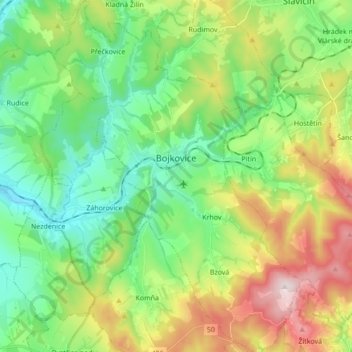
Name: Bojkovice topographic map, elevation, terrain.
Average elevation: 397 m
Minimum elevation: 226 m
Maximum elevation: 736 m
Make a donation
Gear up for your next adventure:
As an Amazon Associate, this site earns from qualifying purchases at no extra cost to you.
Other topographic maps
Click on a map to view its topography, its elevation and its terrain.