Geolocate

San Isabel topographic map

Click on the map to display elevation.

About this map

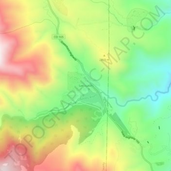
Name: San Isabel topographic map, elevation, terrain.

Location: San Isabel, Custer County, Colorado, United States (37.96751 -105.07444 38.00751 -105.03444)

Average elevation: 2,734 m

Minimum elevation: 2,399 m

Maximum elevation: 3,143 m

Other topographic maps

Click on a map to view its topography, its elevation and its terrain.

Silver Cliff

United States > Colorado > Custer County

Average elevation: 2,507 m

Westcliffe

United States > Colorado > Custer County

Average elevation: 2,404 m

Westcliffe

United States > Colorado > Custer County

Average elevation: 2,404 m

Gear up for your next adventure:

💧Reusable Water Bottle - Durable water bottles for hydration on trails
🚑Survival Whistle - Signal for help across long distances in mountains
Lightweight Backpacking Tent - Compact tent for efficient hiking trips
🥾Durable Hiking Shoes - Long-lasting shoes for frequent hiking
🔪Outdoor Multitool - Versatile tool for repairs and food prep in the wild

As an Amazon Associate, this site earns from qualifying purchases at no extra cost to you.