Geolocate

Fisteus topographic map

Click on the map to display elevation.

About this map

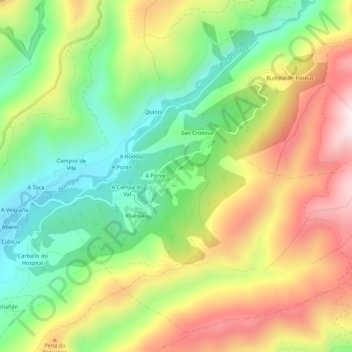
Name: Fisteus topographic map, elevation, terrain.

Location: Fisteus, Quiroga, Lugo, Galicia, 27328, España (42.47598 -7.22458 42.51598 -7.18458)

Average elevation: 576 m

Minimum elevation: 291 m

Maximum elevation: 938 m

Other topographic maps

Click on a map to view its topography, its elevation and its terrain.

A Seara

España > Galicia > Quiroga > Quiroga

Average elevation: 1,160 m

Bendilló

España > Galicia > Quiroga > Quiroga

Average elevation: 701 m

Montefurado

España > Galicia > Quiroga > Quiroga

Average elevation: 523 m

Gear up for your next adventure:

🛶Waterproof Dry Bags - Keep electronics and clothes dry during river crossings
🧢Hiking Sun Hat - Wide-brimmed protection for exposed mountain ridges
🧭Orienteering Kit - Tools for map reading and navigation in the wild
👟Sport Hiking Sandals - Breathable footwear for water crossings and camp rest
🥾Waterproof Hiking Boots - Essential footwear for rugged terrain and wet Canadian trails

As an Amazon Associate, this site earns from qualifying purchases at no extra cost to you.