
Make a donation
Gear up for your next adventure:
As an Amazon Associate, this site earns from qualifying purchases at no extra cost to you.
Weingartshof topographic map
Click on the map to display elevation.
Make a donation
Gear up for your next adventure:
As an Amazon Associate, this site earns from qualifying purchases at no extra cost to you.
About this map
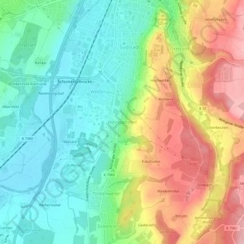
Name: Weingartshof topographic map, elevation, terrain.
Average elevation: 486 m
Minimum elevation: 417 m
Maximum elevation: 594 m
Make a donation
Gear up for your next adventure:
As an Amazon Associate, this site earns from qualifying purchases at no extra cost to you.
Other topographic maps
Click on a map to view its topography, its elevation and its terrain.
Schmalegg
Deutschland > Baden-Württemberg > Landkreis Ravensburg > Ravensburg
Schmalegg liegt auf einer Anhöhe, die das Schussental überblickt.
Average elevation: 540 m
88213
Deutschland > Baden-Württemberg > Landkreis Ravensburg > Ravensburg > Schmalegg > Ganter
Average elevation: 507 m
Schwalbenbach
Deutschland > Baden-Württemberg > Landkreis Ravensburg > Ravensburg > Weißenau
Average elevation: 468 m