Geolocate

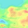
Primavera topographic map

Click on the map to display elevation.

About this map

Name: Primavera topographic map, elevation, terrain.

Location: Primavera, Provincia de Tierra del Fuego, Magallanes and Chilean Antarctica Region, Chile (-53.05129 -70.57016 -52.36970 -68.51480)

Average elevation: 86 m

Minimum elevation: 0 m

Maximum elevation: 543 m

Other topographic maps

Click on a map to view its topography, its elevation and its terrain.
Gear up for your next adventure:

🦌Outdoor Trail Camera - Monitor wildlife activity near your favorite spots
🥾Approach Boots - Comfortable boots for hiking and climbing approaches
🛶Canoe Life Vest - Safety vest for water sports
🧢Hiking Sun Hat - Wide-brimmed protection for exposed mountain ridges
🥘Camping Cookware Set - Compact nesting pots and pans for trail cooking

As an Amazon Associate, this site earns from qualifying purchases at no extra cost to you.