
Make a donation
Gear up for your next adventure:
As an Amazon Associate, this site earns from qualifying purchases at no extra cost to you.
Fermont topographic map
Click on the map to display elevation.
Make a donation
Gear up for your next adventure:
As an Amazon Associate, this site earns from qualifying purchases at no extra cost to you.
Fermont
L'altitude de Fermont varie entre 550 m et 900 m. Son point le plus bas se situe dans la vallée de la rivière aux Pékans, au sud-ouest. Son point le plus élevé se situe dans les monts Seversen. La mine du Mont-Wright a nivelé une grande partie de ces monts. Le mont Daviault offre un point de vue sur la ville.
Make a donation
Gear up for your next adventure:
As an Amazon Associate, this site earns from qualifying purchases at no extra cost to you.
About this map
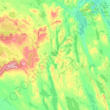
Name: Fermont topographic map, elevation, terrain.
Average elevation: 632 m
Minimum elevation: 501 m
Maximum elevation: 904 m
Make a donation
Gear up for your next adventure:
As an Amazon Associate, this site earns from qualifying purchases at no extra cost to you.
Other topographic maps
Click on a map to view its topography, its elevation and its terrain.
Make a donation
Gear up for your next adventure:
As an Amazon Associate, this site earns from qualifying purchases at no extra cost to you.