Geolocate

Maó topographic map

Click on the map to display elevation.

About this map

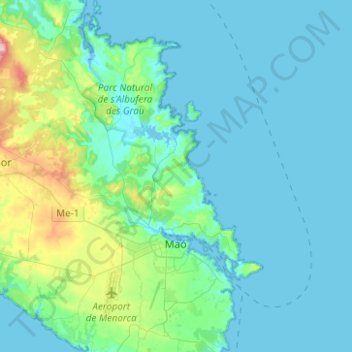
Name: Maó topographic map, elevation, terrain.

Location: Maó, Menorca, Balearic Islands, Spain (39.83089 4.15647 40.02154 4.32803)

Average elevation: 32 m

Minimum elevation: -3 m

Maximum elevation: 220 m

Other topographic maps

Click on a map to view its topography, its elevation and its terrain.

Binidalí

Spain > Balearic Islands > Menorca > Maó

Average elevation: 21 m

Tom de Biniarroi

Spain > Balearic Islands > Menorca > Alaior

Average elevation: 79 m

Son Blanc

Spain > Balearic Islands > Menorca > Ciutadella > sa Caleta

Average elevation: 11 m

es Còdol

Spain > Balearic Islands > Menorca > Alaior

Average elevation: 27 m

Son Oleo

Spain > Balearic Islands > Menorca > Ciutadella

Average elevation: 13 m

Cala Galdana

Spain > Balearic Islands > Menorca > Ferreries

Average elevation: 34 m

Punta Prima

Spain > Balearic Islands > Menorca

Average elevation: 13 m

Son Bou

Spain > Balearic Islands > Menorca > Alaior > Son Bou

Average elevation: 27 m

Cala Morell

Spain > Balearic Islands > Menorca > Ciutadella > Cala Morell

Average elevation: 40 m

Gear up for your next adventure:

Lightweight Backpacking Tent - Compact tent for efficient hiking trips
🧢Beanie Hat - Keep your head warm in cold weather
🥾Mountain Trail Shoes - High-traction shoes for mountain trails
🧤Rechargeable Heated Gloves - Extreme warmth for Canadian winter expeditions
🕶️Polarized Sunglasses - Protect your eyes with durable polarized lenses

As an Amazon Associate, this site earns from qualifying purchases at no extra cost to you.