Geolocate

Ottertail topographic map

Click on the map to display elevation.

About this map
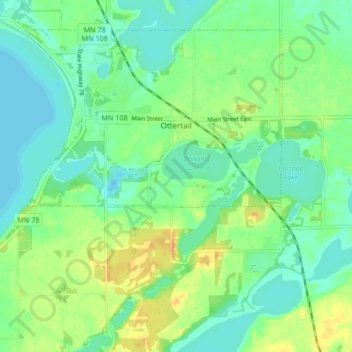
Name: Ottertail topographic map, elevation, terrain.

Location: Ottertail, Otter Tail County, Minnesota, 56571, United States (46.41206 -95.59342 46.44122 -95.53228)

Average elevation: 409 m

Minimum elevation: 398 m

Maximum elevation: 428 m

Other topographic maps

Click on a map to view its topography, its elevation and its terrain.

Luce

United States > Minnesota > Otter Tail County

Average elevation: 419 m

Gear up for your next adventure:

👟Sport Hiking Sandals - Breathable footwear for water crossings and camp rest
🧥Softshell Jacket - Windproof and breathable jacket for hiking
🧴Bear Spray Holster - Quick-access carry for essential Canadian wilderness safety
🧼Travel Hand Sanitizer - Keep hands clean when water is scarce
🛶Waterproof Dry Bags - Keep electronics and clothes dry during river crossings

As an Amazon Associate, this site earns from qualifying purchases at no extra cost to you.