Geolocate

Chandeswar topographic map

Click on the map to display elevation.

About this map

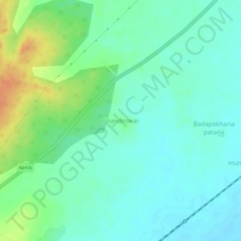
Name: Chandeswar topographic map, elevation, terrain.

Location: Chandeswar, Tangi, Khordha, Odisha, 752023, India (19.87574 85.34715 19.91574 85.38715)

Average elevation: 18 m

Minimum elevation: 6 m

Maximum elevation: 44 m

Gear up for your next adventure:

Bushcraft Tarp - Versatile emergency shelter or gear protection
🧰Multitool Knife - Compact and versatile tool for outdoor use
🧥Ultralight Puffy Jacket - Maximum warmth that packs down to the size of an orange
🧢Beanie Hat - Keep your head warm in cold weather
🦟Insect Repellent - Keep mosquitoes and black flies away in wooded areas

As an Amazon Associate, this site earns from qualifying purchases at no extra cost to you.