Geolocate

Wildwood topographic map

Click on the map to display elevation.

About this map

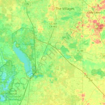
Name: Wildwood topographic map, elevation, terrain.

Location: Wildwood, Sumter County, Florida, United States (28.68783 -82.06437 28.94807 -81.95366)

Average elevation: 23 m

Minimum elevation: 3 m

Maximum elevation: 55 m

Gear up for your next adventure:

🔥Emergency Fire Starter - Reliable ignition source for all weather conditions
🧭GPS Handheld Device - Reliable GPS navigation for outdoor adventures
🧴Insect Repellent - Protect yourself from bugs during outdoor adventures
🧢Outdoor Visor - Breathable visor for sunny hikes
🥾Hiking Shorts - Breathable shorts suitable for summer hikes

As an Amazon Associate, this site earns from qualifying purchases at no extra cost to you.