Geolocate

Joseph topographic map

Click on the map to display elevation.

Joseph

According to the United States Census Bureau, the city has a total area of 0.88 square miles (2.28 km2), all of it land. The elevation is 4,190 feet (1,280 m) above sea level.

Wikipedia (CC-BY-SA 3.0)

About this map

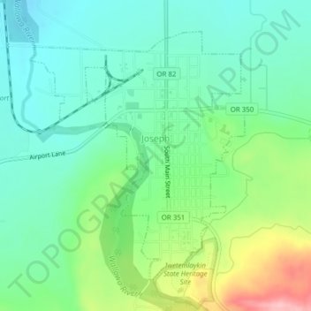
Name: Joseph topographic map, elevation, terrain.

Location: Joseph, Wallowa County, Oregon, 97846, United States (45.33959 -117.24665 45.36118 -117.22024)

Average elevation: 1,285 m

Minimum elevation: 1,235 m

Maximum elevation: 1,404 m

Other topographic maps

Click on a map to view its topography, its elevation and its terrain.

Moccasin Lake

United States > Oregon > Wallowa County

Average elevation: 2,367 m

Gear up for your next adventure:

🥾Light Hiking Boots - Lightweight and comfortable boots for day hikes
🪑Insulated Seat Pad - Protect your seat from cold rocks and wet logs
🥾Hiking Shorts - Breathable shorts suitable for summer hikes
Lightweight Backpacking Tent - Compact tent for efficient hiking trips
🥾Durable Hiking Shoes - Long-lasting shoes for frequent hiking

As an Amazon Associate, this site earns from qualifying purchases at no extra cost to you.