Geolocate

Chatha topographic map

Click on the map to display elevation.

About this map

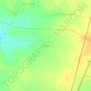
Name: Chatha topographic map, elevation, terrain.

Location: Chatha, Biaora Tahsil, Rajgarh, Madhya Pradesh, India (23.95435 76.88443 23.99435 76.92443)

Average elevation: 428 m

Minimum elevation: 411 m

Maximum elevation: 441 m

Other topographic maps

Click on a map to view its topography, its elevation and its terrain.

Biaora

India > Madhya Pradesh > Biaora Tahsil > Habirpura

Average elevation: 429 m

Gear up for your next adventure:

🩹Compact First Aid Kit - Pre-packed essentials for common trail injuries
🥾Hiking Leggings - Comfortable leggings for outdoor activities
🧦Crew Hiking Socks - Comfortable socks for long-distance hikes
🧰Survival Kit - Essential gear for emergencies in the wilderness
🩹Moleskin Blister Pads - Direct protection for painful foot pressure points

As an Amazon Associate, this site earns from qualifying purchases at no extra cost to you.