Geolocate

Quirinópolis topographic map

Click on the map to display elevation.

About this map

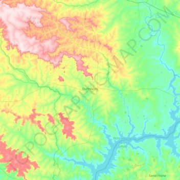
Name: Quirinópolis topographic map, elevation, terrain.

Location: Quirinópolis, Região Geográfica Imediata de Quirinópolis, Região Geográfica Intermediária de Rio Verde, Goiás, Central-West Region, Brazil (-18.77279 -50.96600 -18.13500 -50.09439)

Average elevation: 537 m

Minimum elevation: 396 m

Maximum elevation: 882 m

Other topographic maps

Click on a map to view its topography, its elevation and its terrain.

Bernarda

Brazil > Goiás > São Francisco de Goiás

Average elevation: 736 m

Gercinápolis

Brazil > Goiás > Varjão

Average elevation: 593 m

Cachoeira Santa Bárbara

Brazil > Goiás > Cavalcante

Average elevation: 1,158 m

Gameleira

Brazil > Goiás > Uruaçu

Average elevation: 675 m

Niquelândia

Brazil > Goiás > Niquelândia > Niquelândia

Average elevation: 707 m

Gear up for your next adventure:

🔪Outdoor Multitool - Versatile tool for repairs and food prep in the wild
🌡️Emergency Mylar Blankets - Compact thermal protection for unexpected nights outdoors
🔥Emergency Fire Starter - Reliable ignition source for all weather conditions
🧢Outdoor Visor - Breathable visor for sunny hikes
💡Portable Camping Lamp - Rechargeable lamp for campsite lighting

As an Amazon Associate, this site earns from qualifying purchases at no extra cost to you.