Geolocate

Mount Marrow topographic map

Click on the map to display elevation.

About this map

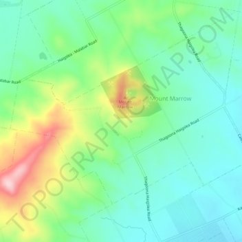
Name: Mount Marrow topographic map, elevation, terrain.

Location: Mount Marrow, Ipswich City, Queensland, Australia (-27.61263 152.59633 -27.58305 152.64506)

Average elevation: 118 m

Minimum elevation: 44 m

Maximum elevation: 287 m

Other topographic maps

Click on a map to view its topography, its elevation and its terrain.

Stanton Cross

Australia > Queensland > Ipswich City

Average elevation: 28 m

Mount Grey

Australia > Queensland > Ipswich City

Average elevation: 231 m

Spring Mountain

Australia > Queensland > Ipswich City

Average elevation: 190 m

White Rock

Australia > Queensland > Ipswich City

Average elevation: 114 m

Gear up for your next adventure:

🥾Light Hiking Boots - Lightweight and comfortable boots for day hikes
🏕️Camping Hammock - Integrated protection for sleeping between trees
👖Convertible Hiking Pants - Zip-off legs to adapt to changing weather conditions
🚲Handlebar Phone Mount - View topographic-map.com live while cycling
🛌Down Sleeping Bag - Superior warmth-to-weight ratio for cold nights

As an Amazon Associate, this site earns from qualifying purchases at no extra cost to you.