Geolocate

Tagmersheim topographic map

Click on the map to display elevation.

About this map
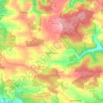
Name: Tagmersheim topographic map, elevation, terrain.

Location: Tagmersheim, Monheim, Landkreis Donau-Ries, Bavaria, 86704, Germany (48.80286 10.91129 48.84363 11.00551)

Average elevation: 516 m

Minimum elevation: 427 m

Maximum elevation: 582 m

Other topographic maps

Click on a map to view its topography, its elevation and its terrain.

Gunzenheim

Germany > Bavaria > Landkreis Donau-Ries

Average elevation: 496 m

Baldingen

Germany > Bavaria > Landkreis Donau-Ries > Nördlingen

Average elevation: 434 m

Holheim

Germany > Bavaria > Landkreis Donau-Ries > Nördlingen

Average elevation: 473 m

Baldingen

Germany > Bavaria > Landkreis Donau-Ries > Nördlingen

Average elevation: 434 m

Holheim

Germany > Bavaria > Landkreis Donau-Ries > Nördlingen

Average elevation: 473 m

Gear up for your next adventure:

🩹Compact First Aid Kit - Pre-packed essentials for common trail injuries
🧥Softshell Jacket - Windproof and breathable jacket for hiking
🧊Insulated Water Bottle - Keeps drinks cold in summer and prevents freezing in winter
💡LED Headlamp - Hands-free illumination for night hiking and camping
🧰Survival Kit - Essential gear for emergencies in the wilderness

As an Amazon Associate, this site earns from qualifying purchases at no extra cost to you.