
Make a donation
Gear up for your next adventure:
As an Amazon Associate, this site earns from qualifying purchases at no extra cost to you.
Lousã topographic map
Click on the map to display elevation.
Make a donation
Gear up for your next adventure:
As an Amazon Associate, this site earns from qualifying purchases at no extra cost to you.
Lousã
Lousã sits at around 200 m (660 ft) high, and it currently has an active station at its aerodrome, but because this station is relatively new, data from the older, now inactive station in the mountains nearby, at a higher altitude, is also represented in the climate chart below.
Make a donation
Gear up for your next adventure:
As an Amazon Associate, this site earns from qualifying purchases at no extra cost to you.
About this map
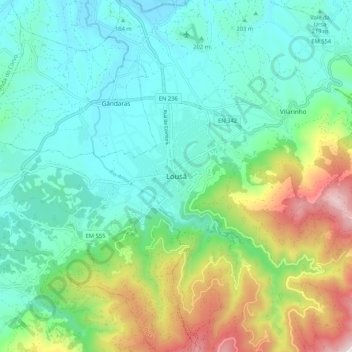
Name: Lousã topographic map, elevation, terrain.
Location: Lousã, Lousã e Vilarinho, Lousã, Coimbra, 3200-200, Portugal (40.07115 -8.28616 40.15115 -8.20616)
Average elevation: 335 m
Minimum elevation: 75 m
Maximum elevation: 1,048 m
Make a donation
Gear up for your next adventure:
As an Amazon Associate, this site earns from qualifying purchases at no extra cost to you.