
Thank you for supporting this site ❤️
Make a donation
Make a donation
Gear up for your next adventure:
As an Amazon Associate, this site earns from qualifying purchases at no extra cost to you.
Baden topographic map
Click on the map to display elevation.
Thank you for supporting this site ❤️
Make a donation
Make a donation
Gear up for your next adventure:
As an Amazon Associate, this site earns from qualifying purchases at no extra cost to you.
About this map
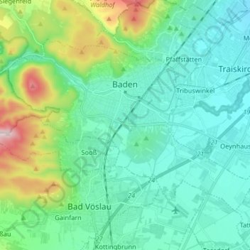
Name: Baden topographic map, elevation, terrain.
Location: Baden, Bezirk Baden, Lower Austria, Austria (47.96386 16.17203 48.02450 16.30320)
Average elevation: 288 m
Minimum elevation: 190 m
Maximum elevation: 652 m
Thank you for supporting this site ❤️
Make a donation
Make a donation
Gear up for your next adventure:
As an Amazon Associate, this site earns from qualifying purchases at no extra cost to you.
Other topographic maps
Click on a map to view its topography, its elevation and its terrain.
Matterhorn
Austria > Lower Austria > Bezirk Baden > Altenmarkt an der Triesting
Average elevation: 526 m