
Bestwig topographic map
Click on the map to display elevation.
About this map
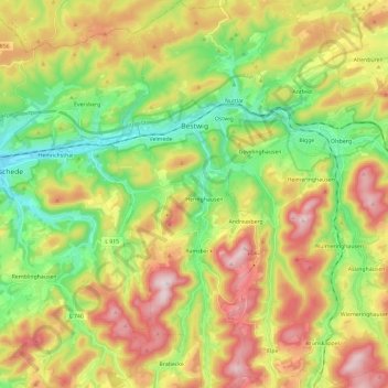
Name: Bestwig topographic map, elevation, terrain.
Average elevation: 466 m
Minimum elevation: 261 m
Maximum elevation: 744 m
Other topographic maps
Click on a map to view its topography, its elevation and its terrain.
Recklinghausen (Sauerland)
Germany > North Rhine-Westphalia > Hochsauerlandkreis > Sundern
Average elevation: 332 m
Gellinghausen
Germany > North Rhine-Westphalia > Hochsauerlandkreis > Schmallenberg > Westernbödefeld
Average elevation: 565 m
Ruhrquelle
Germany > North Rhine-Westphalia > Hochsauerlandkreis > Winterberg > Grönebach
Average elevation: 645 m
Lenneplätze
Germany > North Rhine-Westphalia > Hochsauerlandkreis > Winterberg > Neuastenberg
Average elevation: 699 m
Neuastenberg
Germany > North Rhine-Westphalia > Hochsauerlandkreis > Winterberg
Average elevation: 685 m
Altastenberg
Germany > North Rhine-Westphalia > Hochsauerlandkreis > Winterberg
Average elevation: 708 m
Niedersfeld
Germany > North Rhine-Westphalia > Hochsauerlandkreis > Winterberg
Average elevation: 655 m
Wormbach
Germany > North Rhine-Westphalia > Hochsauerlandkreis > Schmallenberg
Average elevation: 434 m
Hachen
Germany > North Rhine-Westphalia > Hochsauerlandkreis > Sundern > Hachen
Average elevation: 293 m