Geolocate

Butternut topographic map

Click on the map to display elevation.

About this map

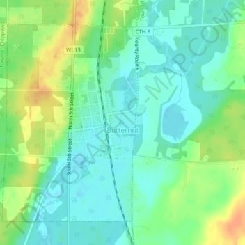
Name: Butternut topographic map, elevation, terrain.

Location: Butternut, Ashland County, Wisconsin, United States (46.00294 -90.50954 46.02472 -90.48781)

Average elevation: 466 m

Minimum elevation: 453 m

Maximum elevation: 489 m

Other topographic maps

Click on a map to view its topography, its elevation and its terrain.

La Pointe

United States > Wisconsin > Ashland County

Average elevation: 186 m

Highbridge

United States > Wisconsin > Ashland County

Average elevation: 295 m

Glidden

United States > Wisconsin > Ashland County

Average elevation: 468 m

Morgan Falls

United States > Wisconsin > Ashland County

Average elevation: 402 m

Marengo

United States > Wisconsin > Ashland County

Average elevation: 240 m

Gear up for your next adventure:

🧭Orienteering Kit - Tools for map reading and navigation in the wild
🥾Trail Hiking Socks - Comfortable socks to prevent blisters and fatigue
💡LED Camping Lantern - Illuminate your campsite with long-lasting lanterns
🥾Hiking Boots - Sturdy boots providing ankle support and traction on rugged trails
🕶️Polarized Sunglasses - Protect your eyes with durable polarized lenses

As an Amazon Associate, this site earns from qualifying purchases at no extra cost to you.