Geolocate

Binaritan topographic map

Click on the map to display elevation.

About this map

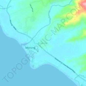
Name: Binaritan topographic map, elevation, terrain.

Location: Binaritan, Morong, Bataan, Central Luzon, 2108, Philippines (14.66012 120.25136 14.70012 120.29136)

Average elevation: 17 m

Minimum elevation: 0 m

Maximum elevation: 153 m

Other topographic maps

Click on a map to view its topography, its elevation and its terrain.

Sabang River

Philippines > Bataan > Morong > Bernabe

Average elevation: 14 m

Gear up for your next adventure:

🕶️Polarized Sunglasses - Protect your eyes with durable polarized lenses
🦶Anti-Blister Balm - Prevents friction and hotspots during long ascents
🥾Durable Hiking Shoes - Long-lasting shoes for frequent hiking
🥾Hiking Shorts - Breathable shorts suitable for summer hikes
🧦Crew Hiking Socks - Comfortable socks for long-distance hikes

As an Amazon Associate, this site earns from qualifying purchases at no extra cost to you.