
Make a donation
Gear up for your next adventure:
As an Amazon Associate, this site earns from qualifying purchases at no extra cost to you.
Beethovenstraße topographic map
Click on the map to display elevation.
Make a donation
Gear up for your next adventure:
As an Amazon Associate, this site earns from qualifying purchases at no extra cost to you.
About this map
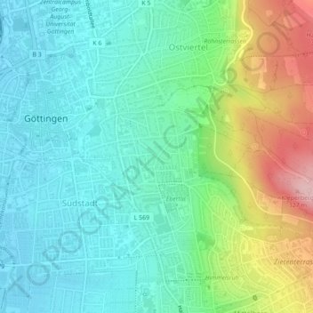
Name: Beethovenstraße topographic map, elevation, terrain.
Average elevation: 201 m
Minimum elevation: 148 m
Maximum elevation: 335 m
Make a donation
Gear up for your next adventure:
As an Amazon Associate, this site earns from qualifying purchases at no extra cost to you.
Other topographic maps
Click on a map to view its topography, its elevation and its terrain.
Stadtwald Göttingen und Kerstlingeröder Feld
Deutschland > Niedersachsen > Landkreis Göttingen > Göttingen
Average elevation: 340 m
Astrid-Lindgren-Schule
Deutschland > Niedersachsen > Landkreis Göttingen > Göttingen
Average elevation: 173 m
Make a donation
Gear up for your next adventure:
As an Amazon Associate, this site earns from qualifying purchases at no extra cost to you.
Breslauer Straße 1
Deutschland > Niedersachsen > Landkreis Göttingen > Göttingen
Average elevation: 199 m