
Make a donation
Gear up for your next adventure:
As an Amazon Associate, this site earns from qualifying purchases at no extra cost to you.
Gaillon-sur-Montcient topographic map
Click on the map to display elevation.
Make a donation
Gear up for your next adventure:
As an Amazon Associate, this site earns from qualifying purchases at no extra cost to you.
About this map
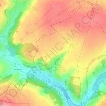
Name: Gaillon-sur-Montcient topographic map, elevation, terrain.
Average elevation: 83 m
Minimum elevation: 20 m
Maximum elevation: 133 m
Make a donation
Gear up for your next adventure:
As an Amazon Associate, this site earns from qualifying purchases at no extra cost to you.
Other topographic maps
Click on a map to view its topography, its elevation and its terrain.
Guyancourt
France > Île-de-France > Yvelines > Guyancourt > Guyancourt
La commune de Guyancourt se situe dans le centre-est des Yvelines. Le territoire communal est situé sur le plateau de Saclay à environ 160 m d’altitude, profondément entaillé dans sa partie nord par la vallée de la Bièvre qui le sépare du plateau de Satory. La vallée de la Bièvre est protégée par…
Average elevation: 155 m