Geolocate

Lantic topographic map

Click on the map to display elevation.

About this map

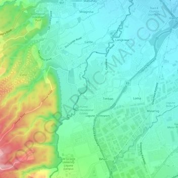
Name: Lantic topographic map, elevation, terrain.

Location: Lantic, Carmona, Cavite, Calabarzon, 4116, Philippines (14.25715 121.00886 14.31103 121.06029)

Average elevation: 70 m

Minimum elevation: 19 m

Maximum elevation: 209 m

Other topographic maps

Click on a map to view its topography, its elevation and its terrain.

Timbao Dam

Philippines > Cavite > Carmona

Average elevation: 76 m

Gear up for your next adventure:

🧴Waterproofing Spray - Restore the DWR coating on jackets and tents
🥾Durable Hiking Shoes - Long-lasting shoes for frequent hiking
💡Compact LED Flashlight - Powerful and portable flashlight for outdoor use
🥘Camping Cookware Set - Compact nesting pots and pans for trail cooking
🧴Sunscreen SPF - Broad-spectrum sunscreen for outdoor activities

As an Amazon Associate, this site earns from qualifying purchases at no extra cost to you.