Geolocate

Tablon topographic map

Click on the map to display elevation.

About this map

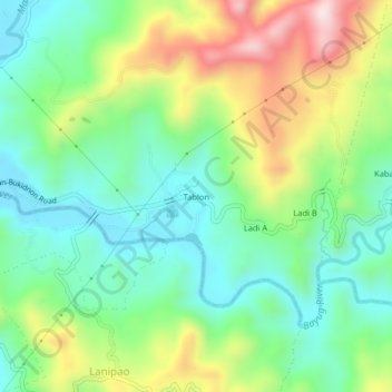
Name: Tablon topographic map, elevation, terrain.

Location: Tablon, Digkila-an, Iligan, Northern Mindanao, Philippines (8.22501 124.32951 8.26501 124.36951)

Average elevation: 185 m

Minimum elevation: 32 m

Maximum elevation: 472 m

Other topographic maps

Click on a map to view its topography, its elevation and its terrain.

Digkila-an

Philippines > Iligan

Average elevation: 151 m

Agus River

Philippines > Iligan > Ditucalan > Upper Taytay

Average elevation: 234 m

Gear up for your next adventure:

🧥Thermal Fleece Jacket - Versatile insulation for changing mountain temperatures
Family Camping Tent - Spacious tent suitable for family camping trips
🧢Sun Hat - Wide-brim hat for sun protection
🐕Hiking Dog Pack - Let your canine companion carry their own water and food
🥾Trail Hiking Socks - Comfortable socks to prevent blisters and fatigue

As an Amazon Associate, this site earns from qualifying purchases at no extra cost to you.