Geolocate

Cardes topographic map

Click on the map to display elevation.

About this map

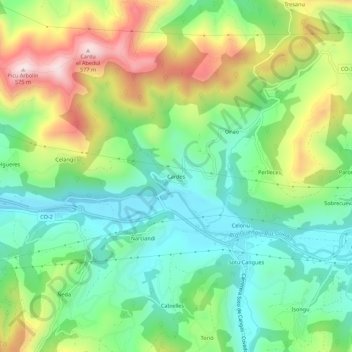
Name: Cardes topographic map, elevation, terrain.

Location: Cardes, Cangas de Onís, Asturias, 33589, España (43.33458 -5.11443 43.37458 -5.07443)

Average elevation: 238 m

Minimum elevation: 63 m

Maximum elevation: 548 m

Gear up for your next adventure:

🧭GPS Handheld Device - Reliable GPS navigation for outdoor adventures
🥾Lightweight Hiking Boots - Boots for comfort and mobility on long hikes
🧤Rechargeable Heated Gloves - Extreme warmth for Canadian winter expeditions
🧴First Aid Kit - Essential first aid supplies for outdoor emergencies
🥾Hiking Shorts - Breathable shorts suitable for summer hikes

As an Amazon Associate, this site earns from qualifying purchases at no extra cost to you.