Geolocate

Redmond topographic map

Click on the map to display elevation.

About this map

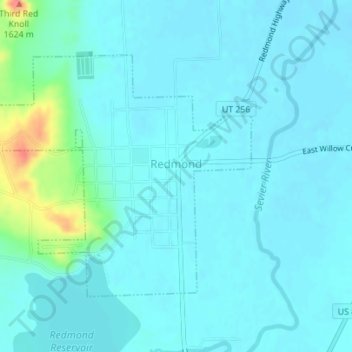
Name: Redmond topographic map, elevation, terrain.

Location: Redmond, Sevier County, Utah, 84652, United States (38.99582 -111.88057 39.01436 -111.85433)

Average elevation: 1,562 m

Minimum elevation: 1,552 m

Maximum elevation: 1,623 m

Other topographic maps

Click on a map to view its topography, its elevation and its terrain.

Monroe Peak

United States > Utah > Sevier County

Average elevation: 3,140 m

Sawtooth

United States > Utah > Sevier County

Average elevation: 2,069 m

Austin

United States > Utah > Sevier County

Average elevation: 1,624 m

Gear up for your next adventure:

🧴Sunscreen SPF - Broad-spectrum sunscreen for outdoor activities
🐕Hiking Dog Pack - Let your canine companion carry their own water and food
🧭GPS Outdoor Watch - Smart watch for navigation and fitness tracking in nature
🔨Vehicle Emergency Tool - Safety tool for remote road trips to trailheads
🥾Trail Hiking Socks - Comfortable socks to prevent blisters and fatigue

As an Amazon Associate, this site earns from qualifying purchases at no extra cost to you.