Geolocate

Mareda topographic map

Click on the map to display elevation.

About this map

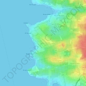
Name: Mareda topographic map, elevation, terrain.

Location: Mareda, Grad Novigrad, Istria County, 52466, Croatia (45.32315 13.52958 45.36315 13.56958)

Average elevation: 13 m

Minimum elevation: -2 m

Maximum elevation: 57 m

Gear up for your next adventure:

👟Leg Gaiters - Keep debris, mud, and snow out of your boots
Camping Coffee Maker - Brew fresh coffee anywhere on the topographic map
🔭Outdoor Binoculars - Lightweight binoculars for birdwatching and hiking
Bushcraft Tarp - Versatile emergency shelter or gear protection
💧Reusable Water Bottle - Durable water bottles for hydration on trails

As an Amazon Associate, this site earns from qualifying purchases at no extra cost to you.