
Make a donation
Gear up for your next adventure:
As an Amazon Associate, this site earns from qualifying purchases at no extra cost to you.
Montagne Noire topographic map
Click on the map to display elevation.
Make a donation
Gear up for your next adventure:
As an Amazon Associate, this site earns from qualifying purchases at no extra cost to you.
About this map
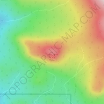
Name: Montagne Noire topographic map, elevation, terrain.
Average elevation: 642 m
Minimum elevation: 494 m
Maximum elevation: 842 m
Make a donation
Gear up for your next adventure:
As an Amazon Associate, this site earns from qualifying purchases at no extra cost to you.
Other topographic maps
Click on a map to view its topography, its elevation and its terrain.
Parc national du Mont-Mégantic
Canada > Québec > Le Haut-Saint-François > La Patrie
Bien que peu fréquentes, des conditions de vent favorables permettent à de nombreux deltistes et parapentistes de s'élancer du sommet du mont Saint-Joseph. Les activités de vol sont supervisées par le club de vol libre de Thetford Mines. Le record d'altitude en deltaplane au Québec s'est fait à partir…
Average elevation: 624 m