Geolocate

Calaocan topographic map

Click on the map to display elevation.

About this map

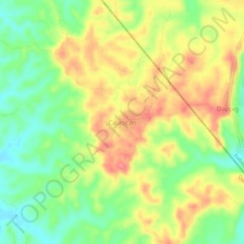
Name: Calaocan topographic map, elevation, terrain.

Location: Calaocan, San Agustin, Quirino, Cagayan Valley, Philippines (16.42796 121.69430 16.46796 121.73430)

Average elevation: 151 m

Minimum elevation: 110 m

Maximum elevation: 193 m

Gear up for your next adventure:

🕶️Polarized Sunglasses - Protect your eyes with durable polarized lenses
🧥Thermal Layer - Insulating layer for cold outdoor conditions
🥾Trail Hiking Socks - Comfortable socks to prevent blisters and fatigue
Camping Coffee Maker - Brew fresh coffee anywhere on the topographic map
🧊Portable Cooler - Keep food and drinks cold during outdoor adventures

As an Amazon Associate, this site earns from qualifying purchases at no extra cost to you.