Geolocate

Arvada topographic map

Click on the map to display elevation.

About this map

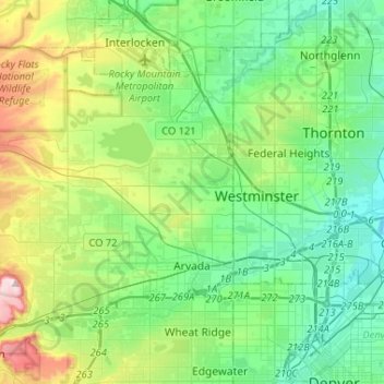
Name: Arvada topographic map, elevation, terrain.

Location: Arvada, Jefferson County, Colorado, United States (39.78438 -105.30192 39.89302 -105.04231)

Average elevation: 1,665 m

Minimum elevation: 1,549 m

Maximum elevation: 1,999 m

Other topographic maps

Click on a map to view its topography, its elevation and its terrain.

Genesee

United States > Colorado > Jefferson County > Golden

Average elevation: 2,249 m

Morrison

United States > Colorado > Jefferson County

Average elevation: 1,892 m

Golden

United States > Colorado > Jefferson County > Golden

Average elevation: 1,916 m

Gear up for your next adventure:

🏃Hydration Running Vest - Carry water and maps close to your body for speed
🔭Compact Monocular - One-handed bird watching and trail spotting
🥾Mountain Hiking Boots - High-traction boots for rocky terrain
🧦Outdoor Socks - Durable socks designed for hiking and outdoor sports
🦟Insect Repellent - Keep mosquitoes and black flies away in wooded areas

As an Amazon Associate, this site earns from qualifying purchases at no extra cost to you.