Geolocate

Greeley topographic map

Click on the map to display elevation.

About this map

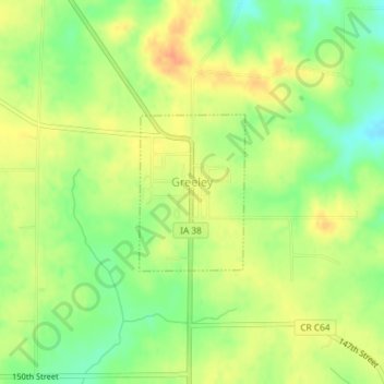
Name: Greeley topographic map, elevation, terrain.

Location: Greeley, Delaware County, Iowa, United States (42.57947 -91.34662 42.59048 -91.33649)

Average elevation: 347 m

Minimum elevation: 324 m

Maximum elevation: 366 m

Gear up for your next adventure:

🥾All-Terrain Hiking Boots - Versatile boots for varied hiking conditions
🧦Thermal Socks - Warm socks for winter hiking or camping
🛏️Camping Sleeping Mat - Comfortable mats for sleeping outdoors
🛶Kayak Dry Bag - Waterproof storage for kayaking adventures
Family Camping Tent - Spacious tent suitable for family camping trips

As an Amazon Associate, this site earns from qualifying purchases at no extra cost to you.