Geolocate

Tryon topographic map

Click on the map to display elevation.

About this map

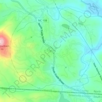
Name: Tryon topographic map, elevation, terrain.

Location: Tryon, Polk County, North Carolina, United States (35.19654 -82.25175 35.21942 -82.22512)

Average elevation: 333 m

Minimum elevation: 272 m

Maximum elevation: 498 m

Other topographic maps

Click on a map to view its topography, its elevation and its terrain.

Mill Spring

United States > North Carolina > Polk County

Average elevation: 318 m

Beulah

United States > North Carolina > Polk County

Average elevation: 287 m

Cox

United States > North Carolina > Polk County

Average elevation: 251 m

Peniel

United States > North Carolina > Polk County

Average elevation: 326 m

Mill Spring

United States > North Carolina > Polk County

Average elevation: 318 m

Howard Gap

United States > North Carolina > Polk County

Average elevation: 573 m

Gear up for your next adventure:

👖Convertible Hiking Pants - Zip-off legs to adapt to changing weather conditions
🧭GPS Handheld Device - Reliable GPS navigation for outdoor adventures
🧴Waterproofing Spray - Restore the DWR coating on jackets and tents
🐕Hiking Dog Pack - Let your canine companion carry their own water and food
🍽️Titanium Camping Spork - Ultralight and indestructible eating utensil

As an Amazon Associate, this site earns from qualifying purchases at no extra cost to you.