
Kışlaköy Köyü topographic map
Interactive map
Click on the map to display elevation.
About this map
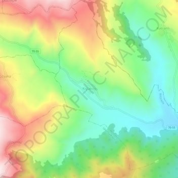
Name: Kışlaköy Köyü topographic map, elevation, terrain.
Location: Kışlaköy Köyü, Başyayla, Karaman, Zentralanatolien, Türkei (36.70840 32.71366 36.75312 32.76561)
Average elevation: 1,057 m
Minimum elevation: 808 m
Maximum elevation: 1,397 m
Other topographic maps
Click on a map to view its topography, its elevation and its terrain.
Göztepe Mahallesi
Türkei > Başyayla > Başyayla Merkez
Göztepe Mahallesi, Başyayla Merkez, Başyayla, Karaman, Zentralanatolien, Türkei
Average elevation: 1,671 m