
Make a donation
Gear up for your next adventure:
As an Amazon Associate, this site earns from qualifying purchases at no extra cost to you.
Parseierspitze topographic map
Click on the map to display elevation.
Make a donation
Gear up for your next adventure:
As an Amazon Associate, this site earns from qualifying purchases at no extra cost to you.
Parseierspitze
Die Parseierspitze ist mit einer Höhe von 3036 m ü. A. der höchste Gipfel der nördlichen Kalkalpen und deren einziger Dreitausender. Die im österreichischen Bundesland Tirol gelegene Spitze ist der Hauptgipfel der Lechtaler Alpen. Erstmals bestiegen wurde sie am 23. August 1869 von Josef Anton Specht und dem Bergführer Peter Siess aus Grins im Stanzer Tal.
Make a donation
Gear up for your next adventure:
As an Amazon Associate, this site earns from qualifying purchases at no extra cost to you.
About this map
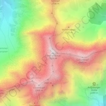
Name: Parseierspitze topographic map, elevation, terrain.
Location: Parseierspitze, Grins, Bezirk Landeck, Tirol, 6571, Österreich (47.17422 10.47818 47.17432 10.47828)
Average elevation: 2,414 m
Minimum elevation: 1,737 m
Maximum elevation: 3,009 m
Make a donation
Gear up for your next adventure:
As an Amazon Associate, this site earns from qualifying purchases at no extra cost to you.