
Make a donation
Gear up for your next adventure:
As an Amazon Associate, this site earns from qualifying purchases at no extra cost to you.
Oberschwarzach topographic map
Click on the map to display elevation.
Make a donation
Gear up for your next adventure:
As an Amazon Associate, this site earns from qualifying purchases at no extra cost to you.
About this map
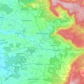
Name: Oberschwarzach topographic map, elevation, terrain.
Average elevation: 319 m
Minimum elevation: 237 m
Maximum elevation: 478 m
Make a donation
Gear up for your next adventure:
As an Amazon Associate, this site earns from qualifying purchases at no extra cost to you.
Other topographic maps
Click on a map to view its topography, its elevation and its terrain.
Handthal
Deutschland > Bayern > Landkreis Schweinfurt
Den Mittelpunkt der Siedlung bildet die katholische Filialkirche St. Maria Magdalena. Ursprünglich stand sie auf der Höhe des Madgalenenberges und war das Ziel vieler Pilger. Sie wurde 1729 geweiht. Im Jahr 1810 wurde den Handthalern der Wiederaufbau der aufgelösten Hospizkirche genehmigt und die…
Average elevation: 380 m
Make a donation
Gear up for your next adventure:
As an Amazon Associate, this site earns from qualifying purchases at no extra cost to you.
Oberwerrn
Deutschland > Bayern > Landkreis Schweinfurt > Oberwerrn
Der Fluss Wern durchfließt in einer über 100 m breiten Talsohle die Gemarkung von NW nach SO. Im Ortsbereich beträgt der Höhenunterschied vom Werntalgrund (234 m ü. NN) zu den Höhen (ca. 265 m ü. NN) gut 30 m. Die durch die Flußeinschneidung angeschnittenen Gesteinsschichten des Unterkeupers sind nur…
Average elevation: 256 m
Make a donation
Gear up for your next adventure:
As an Amazon Associate, this site earns from qualifying purchases at no extra cost to you.
Vasbühl
Deutschland > Bayern > Landkreis Schweinfurt
Vasbühl liegt fünf Kilometer nordwestlich von Werneck auf einem Höhenrücken zwischen Schwebenried und Egenhausen. Im Ortsgebiet entspringt der Dorfgraben, ein Quellfluss der Wern.
Average elevation: 301 m
Make a donation
Gear up for your next adventure:
As an Amazon Associate, this site earns from qualifying purchases at no extra cost to you.
Make a donation
Gear up for your next adventure:
As an Amazon Associate, this site earns from qualifying purchases at no extra cost to you.
Make a donation
Gear up for your next adventure:
As an Amazon Associate, this site earns from qualifying purchases at no extra cost to you.
Make a donation
Gear up for your next adventure:
As an Amazon Associate, this site earns from qualifying purchases at no extra cost to you.