
Thank you for supporting this site ❤️
Make a donation
Make a donation
Gear up for your next adventure:
As an Amazon Associate, this site earns from qualifying purchases at no extra cost to you.
Kelang topographic map
Click on the map to display elevation.
Thank you for supporting this site ❤️
Make a donation
Make a donation
Gear up for your next adventure:
As an Amazon Associate, this site earns from qualifying purchases at no extra cost to you.
About this map
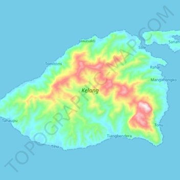
Name: Kelang topographic map, elevation, terrain.
Location: Kelang, Tihu, Seram Bagian Barat, Moluccas, Indonesia (-3.26049 127.63811 -3.15121 127.80070)
Average elevation: 94 m
Minimum elevation: 0 m
Maximum elevation: 747 m
Thank you for supporting this site ❤️
Make a donation
Make a donation
Gear up for your next adventure:
As an Amazon Associate, this site earns from qualifying purchases at no extra cost to you.