
Concord topographic map
Click on the map to display elevation.
About this map
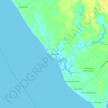
Name: Concord topographic map, elevation, terrain.
Location: Concord, Gloucester County, Virginia, United States (37.34348 -76.63857 37.38348 -76.59857)
Average elevation: 5 m
Minimum elevation: -2 m
Maximum elevation: 24 m
Other topographic maps
Click on a map to view its topography, its elevation and its terrain.
Ware River
United States > Virginia > Gloucester County > Gloucester Courthouse
Average elevation: 3 m