
Make a donation
Gear up for your next adventure:
As an Amazon Associate, this site earns from qualifying purchases at no extra cost to you.
Alexandreia topographic map
Click on the map to display elevation.
Make a donation
Gear up for your next adventure:
As an Amazon Associate, this site earns from qualifying purchases at no extra cost to you.
Alexandreia
Alexandreia is a located in the vast plain north of the river Aliakmonas and west of the river Axios, named Kampania or also Roumlouki. Its economy is chiefly based on the agricultural utilization of the surrounding fields. The area around Alexandreia has the greatest production of peaches in Greece and apples, pears, tobacco, and cotton are also grown at large. Its elevation is 10 m above mean sea level. Alexandreia is 19 km south of Giannitsa, 23 km northeast of Veroia and 42 km west of Thessaloniki.
Make a donation
Gear up for your next adventure:
As an Amazon Associate, this site earns from qualifying purchases at no extra cost to you.
About this map
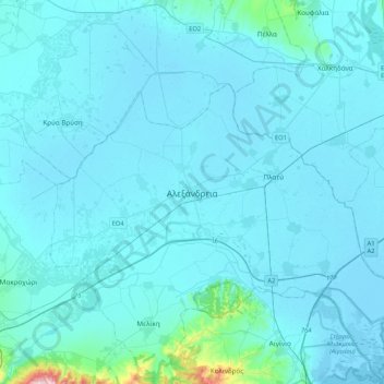
Name: Alexandreia topographic map, elevation, terrain.
Average elevation: 24 m
Minimum elevation: -4 m
Maximum elevation: 535 m
Make a donation
Gear up for your next adventure:
As an Amazon Associate, this site earns from qualifying purchases at no extra cost to you.
Other topographic maps
Click on a map to view its topography, its elevation and its terrain.