
Make a donation
Gear up for your next adventure:
As an Amazon Associate, this site earns from qualifying purchases at no extra cost to you.
Beverly Hills topographic map
Click on the map to display elevation.
Make a donation
Gear up for your next adventure:
As an Amazon Associate, this site earns from qualifying purchases at no extra cost to you.
About this map
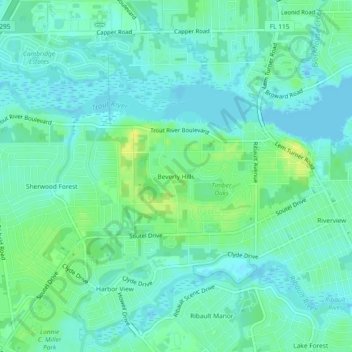
Name: Beverly Hills topographic map, elevation, terrain.
Average elevation: 7 m
Minimum elevation: -3 m
Maximum elevation: 20 m
Make a donation
Gear up for your next adventure:
As an Amazon Associate, this site earns from qualifying purchases at no extra cost to you.
Other topographic maps
Click on a map to view its topography, its elevation and its terrain.
Ribault River
United States > Florida > Duval County > Jacksonville > Lake Forest Hills
Ribault River is a tributary of the Trout River. It is located entirely in Jacksonville, Florida. The river is named after Jean Ribault, a French naval officer. The river's headwaters are near Old Kings Road at an elevation of 7 feet (2.1 m) above sea level. The river cuts through the forest floor near its…
Average elevation: 7 m
Little Talbot Island State Park
United States > Florida > Duval County > Jacksonville
Average elevation: 1 m