
Thank you for supporting this site ❤️
Make a donation
Make a donation
Gear up for your next adventure:
As an Amazon Associate, this site earns from qualifying purchases at no extra cost to you.
Lagomarsino topographic map
Click on the map to display elevation.
Thank you for supporting this site ❤️
Make a donation
Make a donation
Gear up for your next adventure:
As an Amazon Associate, this site earns from qualifying purchases at no extra cost to you.
About this map
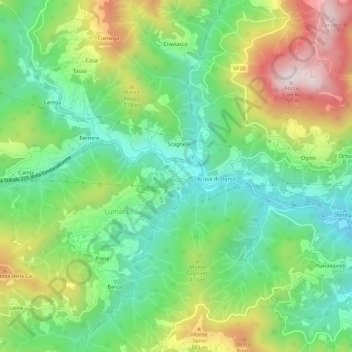
Name: Lagomarsino topographic map, elevation, terrain.
Location: Lagomarsino, Lumarzo, Genoa, Liguria, 16024, Italy (44.41769 9.13121 44.45769 9.17121)
Average elevation: 375 m
Minimum elevation: 148 m
Maximum elevation: 766 m
Thank you for supporting this site ❤️
Make a donation
Make a donation
Gear up for your next adventure:
As an Amazon Associate, this site earns from qualifying purchases at no extra cost to you.