
Wolferstedt topographic map
Interactive map
Click on the map to display elevation.
About this map
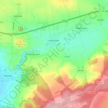
Name: Wolferstedt topographic map, elevation, terrain.
Average elevation: 194 m
Minimum elevation: 127 m
Maximum elevation: 294 m
Other topographic maps
Click on a map to view its topography, its elevation and its terrain.
Rohnetal
Deutschland > Sachsen-Anhalt > Mansfeld-Südharz > Allstedt > Wolferstedt
Rohnetal, Wolferstedt, Allstedt, Mansfeld-Südharz, Sachsen-Anhalt, 06542, Deutschland
Average elevation: 172 m
Niederröblingen (Helme)
Deutschland > Sachsen-Anhalt > Mansfeld-Südharz > Allstedt
Niederröblingen (Helme), Allstedt, Mansfeld-Südharz, Sachsen-Anhalt, Deutschland
Average elevation: 141 m
Emseloh
Deutschland > Sachsen-Anhalt > Mansfeld-Südharz > Allstedt
Emseloh, Allstedt, Mansfeld-Südharz, Sachsen-Anhalt, Deutschland
Average elevation: 278 m
Katharinenrieth
Deutschland > Sachsen-Anhalt > Mansfeld-Südharz > Allstedt
Katharinenrieth, Allstedt, Mansfeld-Südharz, Sachsen-Anhalt, Deutschland
Average elevation: 124 m