Geolocate

Belhi topographic map

Click on the map to display elevation.

About this map

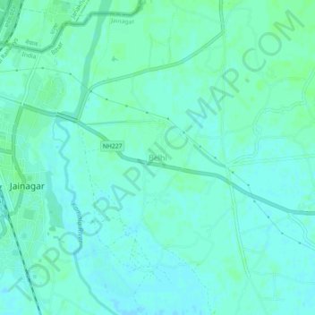
Name: Belhi topographic map, elevation, terrain.

Location: Belhi, Jainagar, Madhubani District, Bihar, India (26.57173 86.13885 26.61173 86.17885)

Average elevation: 71 m

Minimum elevation: 68 m

Maximum elevation: 74 m

Gear up for your next adventure:

🥽Outdoor Goggles - Protective eyewear for outdoor activities
🪑Ultralight Camping Stool - Compact seating for rest stops during long hikes
🧤Insulated Winter Gloves - Heavy-duty protection for sub-zero Canadian adventures
👟Leg Gaiters - Keep debris, mud, and snow out of your boots
🕶️Polarized Sunglasses - Protect your eyes with durable polarized lenses

As an Amazon Associate, this site earns from qualifying purchases at no extra cost to you.