Geolocate

Vesuvius topographic map

Click on the map to display elevation.

About this map

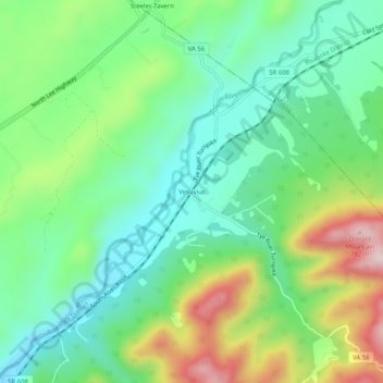
Name: Vesuvius topographic map, elevation, terrain.

Location: Vesuvius, Rockbridge County, Virginia, 24472, United States (37.88624 -79.21725 37.92624 -79.17725)

Average elevation: 526 m

Minimum elevation: 397 m

Maximum elevation: 787 m

Other topographic maps

Click on a map to view its topography, its elevation and its terrain.

Glasgow

United States > Virginia > Rockbridge County

Average elevation: 284 m

Hays Creek

United States > Virginia > Rockbridge County

Average elevation: 438 m

Goshen

United States > Virginia > Rockbridge County

Average elevation: 472 m

Gear up for your next adventure:

💧Hydration Pack - Hands-free hydration system for long hikes
🧊Insulated Water Bottle - Keeps drinks cold in summer and prevents freezing in winter
🥾Waterproof Hiking Boots - Essential footwear for rugged terrain and wet Canadian trails
🥾Trail Hiking Boots - Supportive boots for rough trails
🪜Heavy Duty Carabiners - Multi-use clips for securing gear to your backpack

As an Amazon Associate, this site earns from qualifying purchases at no extra cost to you.