Geolocate

Ciloto topographic map

Click on the map to display elevation.

About this map

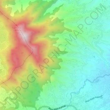
Name: Ciloto topographic map, elevation, terrain.

Location: Ciloto, Cianjur, West Java, Java, 43253, Indonesia (-6.73319 106.99003 -6.69319 107.03003)

Average elevation: 1,286 m

Minimum elevation: 1,018 m

Maximum elevation: 1,802 m

Other topographic maps

Click on a map to view its topography, its elevation and its terrain.

Sindangbarang

Indonesia > West Java > Cianjur

Average elevation: 148 m

Kertamukti

Indonesia > West Java > Cianjur

Average elevation: 25 m

Wangunjaya

Indonesia > West Java > Cianjur

Average elevation: 17 m

Alun Alun Suryakancana

Indonesia > West Java > Cianjur

Average elevation: 2,568 m

Gear up for your next adventure:

🧤Rechargeable Heated Gloves - Extreme warmth for Canadian winter expeditions
🥾Lightweight Hiking Boots - Boots for comfort and mobility on long hikes
🛶Kayak Accessories - Essential gear for safe and fun kayaking adventures
🔦LED Flashlight - Powerful and long-lasting flashlight for camping and emergencies
🚲Handlebar Phone Mount - View topographic-map.com live while cycling

As an Amazon Associate, this site earns from qualifying purchases at no extra cost to you.