Geolocate

Superga topographic map

Click on the map to display elevation.

About this map

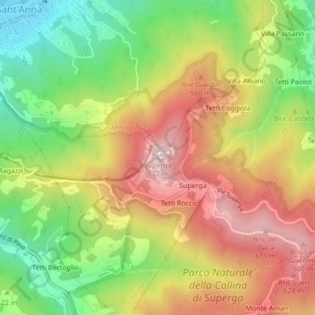
Name: Superga topographic map, elevation, terrain.

Location: Superga, Torino, Piemonte, 10099, Italia (45.08046 7.76705 45.08056 7.76715)

Average elevation: 446 m

Minimum elevation: 210 m

Maximum elevation: 687 m

Other topographic maps

Click on a map to view its topography, its elevation and its terrain.

Mirafiori Sud

Italia > Piemonte > Torino > Torino

Average elevation: 245 m

Circoscrizione 1

Italia > Piemonte > Torino > Torino

Average elevation: 254 m

Parco del Valentino

Italia > Piemonte > Torino > Torino

Average elevation: 269 m

Parco del Valentino

Italia > Piemonte > Torino > Torino

Average elevation: 269 m

Mirafiori Sud

Italia > Piemonte > Torino > Torino

Average elevation: 245 m

Parco Dora (area Michelin)

Italia > Piemonte > Torino > Torino

Average elevation: 249 m

Gear up for your next adventure:

🧥Waterproof Hiking Jacket - Protect yourself from rain and wind while hiking
👟Sport Hiking Sandals - Breathable footwear for water crossings and camp rest
🧢Beanie Hat - Keep your head warm in cold weather
🚲MTB Frame Bag - Carry tools and maps directly on your bicycle frame
🧢Sun Protection Cap - Breathable cap to protect from sun exposure

As an Amazon Associate, this site earns from qualifying purchases at no extra cost to you.