
Nigtevecht topographic map
Interactive map
Click on the map to display elevation.
About this map
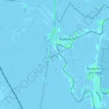
Name: Nigtevecht topographic map, elevation, terrain.
Location: Nigtevecht, Stichtse Vecht, Utrecht, Niederlande (52.25010 5.01492 52.28932 5.06590)
Average elevation: -1 m
Minimum elevation: -6 m
Maximum elevation: 3 m
Other topographic maps
Click on a map to view its topography, its elevation and its terrain.
Breukelen
Niederlande > Utrecht > Stichtse Vecht
Breukelen, Stichtse Vecht, Utrecht, Niederlande
Average elevation: 0 m
Stichtse Vecht
Niederlande > Utrecht > Stichtse Vecht
Stichtse Vecht, Utrecht, Niederlande
Average elevation: -1 m
Nieuwer Ter Aa
Niederlande > Utrecht > Stichtse Vecht
Nieuwer Ter Aa, Stichtse Vecht, Utrecht, Niederlande
Average elevation: -1 m
Oud Zuilen
Niederlande > Utrecht > Stichtse Vecht
Oud Zuilen, Stichtse Vecht, Utrecht, Niederlande
Average elevation: 2 m
Loenersloot
Niederlande > Utrecht > Stichtse Vecht
Loenersloot, Stichtse Vecht, Utrecht, Niederlande
Average elevation: -1 m