
Make a donation
Gear up for your next adventure:
As an Amazon Associate, this site earns from qualifying purchases at no extra cost to you.
Dedham topographic map
Click on the map to display elevation.
Make a donation
Gear up for your next adventure:
As an Amazon Associate, this site earns from qualifying purchases at no extra cost to you.
Dedham
Two McDonnell F-101 Voodoo fighters of the 75th Fighter Squadron were scrambled from Dow Air Force Base on the night of 11 April 1961 to intercept an unidentified aircraft approaching the United States. SAGE identified the incoming aircraft as a Strategic Air Command bomber shortly after the fighters were airborne. The fighters' return to Dow was complicated by a light spring rainstorm, creating an icy runway under a 500-foot cloud ceiling. Dow's tactical air navigation system glide slope function was temporarily disabled after the first aircraft landed. The second aircraft was cleared to descend to 2,200 feet, using a two-dimensional radar approach, when it hit Bald Mountain at an elevation of 1,200 feet. Both crewmen in the second aircraft were killed. Investigators concluded the airfield elevation had been incorrectly set on the aircraft altimeter, creating a 1000-foot error unrecognized when aircrew acknowledged only the last two digits of altimeter readings in radio transmissions.
Make a donation
Gear up for your next adventure:
As an Amazon Associate, this site earns from qualifying purchases at no extra cost to you.
About this map
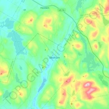
Name: Dedham topographic map, elevation, terrain.
Location: Dedham, Hancock County, Maine, 04429, United States (44.63872 -68.69093 44.75218 -68.50292)
Average elevation: 112 m
Minimum elevation: 14 m
Maximum elevation: 374 m
Make a donation
Gear up for your next adventure:
As an Amazon Associate, this site earns from qualifying purchases at no extra cost to you.
Other topographic maps
Click on a map to view its topography, its elevation and its terrain.