
Thank you for supporting this site ❤️
Make a donation
Make a donation
Gear up for your next adventure:
As an Amazon Associate, this site earns from qualifying purchases at no extra cost to you.
Marsac topographic map
Click on the map to display elevation.
Thank you for supporting this site ❤️
Make a donation
Make a donation
Gear up for your next adventure:
As an Amazon Associate, this site earns from qualifying purchases at no extra cost to you.
About this map
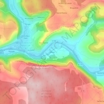
Name: Marsac topographic map, elevation, terrain.
Average elevation: 263 m
Minimum elevation: 118 m
Maximum elevation: 392 m
Thank you for supporting this site ❤️
Make a donation
Make a donation
Gear up for your next adventure:
As an Amazon Associate, this site earns from qualifying purchases at no extra cost to you.
Other topographic maps
Click on a map to view its topography, its elevation and its terrain.
Espace naturel sensible du cirque de Bône
France > Occitanie > Tarn-et-Garonne > Saint-Antonin-Noble-Val > Careme
Average elevation: 268 m
Point Accueil Jeunes (PAJ) de Saint-Antonin
France > Occitanie > Tarn-et-Garonne > Saint-Antonin-Noble-Val
Average elevation: 233 m