Geolocate

南台 topographic map

Click on the map to display elevation.

About this map

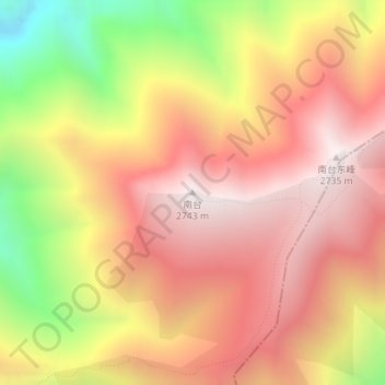
Name: 南台 topographic map, elevation, terrain.

Location: 南台, Zhangjiakou, Hebei, China (39.86465 114.99650 39.86475 114.99660)

Average elevation: 2,294 m

Minimum elevation: 1,594 m

Maximum elevation: 2,742 m

Other topographic maps

Click on a map to view its topography, its elevation and its terrain.

Chongli District

China > Hebei > Zhangjiakou

Average elevation: 1,448 m

Dongwangshan

China > Hebei > Zhangjiakou

Average elevation: 1,038 m

Qiaoxi District

China > Hebei > Zhangjiakou

Average elevation: 917 m

Zhuolu County

China > Hebei > Zhangjiakou

Average elevation: 1,036 m

Huai'an County

China > Hebei > Zhangjiakou

Average elevation: 1,103 m

Gear up for your next adventure:

🪑Insulated Seat Pad - Protect your seat from cold rocks and wet logs
💡LED Headlamp - Hands-free illumination for night hiking and camping
Lightweight Camping Tent - Portable shelter optimized for Canadian backcountry camping
🥾Lightweight Hiking Boots - Boots for comfort and mobility on long hikes
🧦Hiking Liner Socks - Thin base layer to prevent friction and blisters

As an Amazon Associate, this site earns from qualifying purchases at no extra cost to you.